TCTrail
Previous Posts
- St John's branch 2
- Kettle Valley - 07 March 2008
- Nashwaak subdivision
- Tormentine subdivision
- Port aux Basques subdivision
- St John's branch
- Whitbourne branch
- Smiths Falls sub 2
- Maniwaki sub 3
- Maniwaki sub 2
Saturday, April 22, 2006
Smiths Falls subdivision
The Smiths Falls subdivision begins at mile 0, Federal, the junction with the Beachburg subdivision in Ottawa (Nepean township, concession A, lot 28). The Canadian Northern railway built the line from Federal to Sydenham in 1913. From the western terminus at Napanee, the Bay of Quinte railway had built the line to Yarker in 1884 (to Harrowsmith in 1889 and to Sydenham in 1893).
The line from Smiths Falls through to Strathcona was abandoned by Canadian National in 1984. The Cataraqui Trail now occupies the right-of-way (2006). Kilometre 0 of the Cataraqui Trail is located behind the Harveys restaurant on the south end of Smiths Falls along highway 15. Segments of the Smiths Falls subdivision also host the Rideau Trail.
The line from Federal to Smiths Falls (the CPR station) is now owned and operated by VIA Rail Canada. The Ottawa Central railway has trackage rights.
Oil tanks are located at mile post 1.2 (from the junction at Federal (Ottawa) with the Beachburg subdivision.

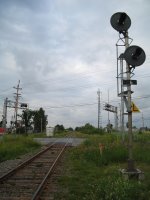
 Signals (originally number mp1.6) are located immediately west of the level crossing of Merivale Road, Ottawa.
At the Rideau Canal (mile 35.5), the spectacular bridge is encountered. In 1914, the Scherzer rolling lift bridge was opened. It was built by Lachine's Dominion Bridge Company and could lift the rails the full 90 degrees in twenty minutes. By the end of 1978, the bridge was closed to traffic. Since that time, the bridge rests in its in raised position.


 At the southern entrance to Smiths Falls, most of the all-wood yard limit sign still stands proud (2005).

 Mile post sign at mile 37 seems a bit less proud.

 The Smiths Falls advance yard limit sign has also seen better days.
  The flag-stop station at Chaffeys Locks survives (2006).


 Signals (originally number mp1.6) are located immediately west of the level crossing of Merivale Road, Ottawa.
 The Smiths Falls CNR station now hosts the Smiths Falls Railway Museum of Eastern Ontario.


 6591 was the regular switcher at the CP yards in Smiths Falls.
 Smiths Falls station is located at mile post 35.1.
 The ten-wheeler was built in 1912.
At the Rideau Canal (mile 35.5), the spectacular bridge is encountered. In 1914, the Scherzer rolling lift bridge was opened. It was built by Lachine's Dominion Bridge Company and could lift the rails the full 90 degrees in twenty minutes. By the end of 1978, the bridge was closed to traffic. Since that time, the bridge rests in its in raised position.
At the southern entrance to Smiths Falls, most of the all-wood yard limit sign still stands proud (2005).
Mile post sign at mile 37 seems a bit less proud.
The Smiths Falls advance yard limit sign has also seen better days.
The flag-stop station at Chaffeys Locks survives (2006).
Oakville subdivision
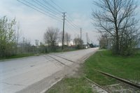
This view looks north towards 880 Avonhead Road, less than a mile from the Trans-Canada Trail (May 2005).

Archives
April 2006 May 2006 June 2006 September 2006 May 2007 June 2007 November 2007 July 2008
![]()